Showing posts with label Moab. Show all posts

Monday, June 10, 2013

Redtail Aviation Scenic Flight

Holy sh*t, this weekend was amazing!  I finally checked a big item off my bucket list and took a scenic flight over Canyonlands.  As long as I've lived in Utah, I've wanted to hop in a tiny plane and get a bird's-eye view of the red rock desert below.  Sufficed to say ... it was amazeballs.


We booked the Canyonlands Tour with Red Tail Aviation, then drove to the tiny Moab airport in the morning.  We hopped in the Cessna 172 with our pilot Jim and took off.  The views were incredible, Jim was a fantastic guy, and we took some great photos.  It was amazing, even though I got a little green when we hit turbulents.   But besides all that... seeing this world from the air gave me a deep sense of satisfaction.  I've spent the last 5 years hiking, biking, and kayaking all over this desert and seeing everything from ground level.  But being up at 7,000' let me see the big picture -- a landscape that can seem like a convoluted maze suddenly revealed its order and patterns.  I could look across an endless red world of spires, canyons, buttes, and mountains to see how everything fit together.  Seriously amazing.  I can't seem to find the right words to do it justice, so I'll let the photos take it from here:


confluence of the Green and Colorado


Dead Horse Point
potash ponds

Monday, May 20, 2013

Klonzo Mtb. Trails

We just hit the mountain bike trail jackpot!  After all the running around and planning of getting married last week, we were in the mood to take it easy and stay close to home.  Jordan had been hearing good things about the Klonzo Trail near Moab, so we drove an hour south to the trail head to check it out.

It ended up being the perfect spring day: 70 degrees, a sky was filled with puffy white clouds, and blooming desert flowers.  And the trails were incredible!  It was a totally different kind of Moab riding.  Moab trails tend to be technical and rocky (Slickrock, anyone?), but my favorite rides tend to be flowy and smooth like the volcanic tuft out in Fruita, CO.  Klonzo was the best of both worlds:  we had the red-rock desert of Moab with the flow trails of Fruita.  Awesome.


spiny hopsage

Like all the best trail systems, the Klonzo Trails make several concentric loop trails.  The seven trails of Klonzo are Boondocks, Borderline, Dunestone, Cross Canyon, Secret Passage, Snippet, and Wahoo.  Everything is ridiculously well marked -- there are signs at every intersection complete with 'you are here' markers.  You can piece the trails together however you want for a variety of riding experiences.

For the most part, these trails are smooth and flowy.  They're perfect for early-intermediate riders.  There are couple steep, tight spots and short climbs that might make true beginners nervous, but for the most part it's totally manageable.  Adrenaline junkies might be a little bored, but even more expert riders could enjoy these trails by riding faster and hammering out all the loops in a solid 12-mile ride.


whipple's fishhook

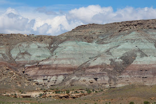
crazy turquoise of the Brushy Basin Member


To get to the Klonzo trailhead, drive along Highway 191 18 miles south of I-70 or about 10 miles north of Moab.  You'll see a sign that says "Willow Springs Road."  Turn here.  After about 1.4 miles, turn left to cross Courthouse Wash, and at mile 2.0 you'll go past the Soverign Trail parking area.  At mile 2.7, turn left off Willow Springs Road onto a small doubletrack.  100 feet later, park and begin your ride.

longnose leopard lizard


map credit:  blm.gov


Wednesday, January 2, 2013

New Year's in Moab

Happy New Year!  Sweetbabyjebus, 2012 was a big one.  I always get cheesy and retrospective at the end of the year, especially since December 31 is my birthday.  So as I turned 29 and 2012 drew to a close, I scanned over this blog to relive some of my favorite adventures.  This has to be one of my best years out in Utah -- we did so much stuff!  Jordan and I got engaged and I bought a mountain bike.  We floated the San Juan River, explored the Black Hills, delved into the Black Canyon of the Gunnsion, backpacked Grand Gulch, ran a half marathon, rappelled the Goblin's Lair with my sister, etc., etc., etc.  Holy shit, I'm lucky.  Looking back on everything makes me realize how fortunate I am to live in such a cool place and be able to spend so much time exploring it.  Hells yeah!

Anyway, this New Year's Eve was the perfect end to a great year.  Shasta, my best friend from back home, finally came out to visit!  We had a blast.  I got to show her Goblin Valley, Dead Horse Point, Arches, and Canyonlands.  We ran around and took a bunch of pictures.  It's always fun to experience Utah through the eyes of someone who's never been here before and see things with a fresh perspective.

We hailed in the New Year with a bunch of friends at the infamous Woody's Tavern.  Huge success!
Dead Horse Point
Dead Horse Point

Canyonlands
New Year's Eve at Woody's
New Year's day @ Arches


Monday, December 3, 2012

La Sal Mt. Christmas Tree

It's officially December -- time to find a Christmas tree!  The temperatures are still hovering in the 50s down in the desert, so we drove up to the LaSal Moutains to have our first semi-snowy excursion of the winter.


50-degree red rock desert doesn't look like a promising start, but ...

During the week, we stopped by the US Forest Service office in Moab to grab a permit, which only costs $10.  They're open weekdays from 8:00am - 4:30pm.  For that price, you can cut down a tree up to 8 feet tall.  Pretty sweet deal.


On Sunday, we started the drive up into the mountains.  The LaSals aren't really that snowy yet, which was a little disconcerting.  It was 56 degrees down in the desert and there wasn't a speck of snow on the red rocks, so it was hard to feel super-Christmasy.  But as we started driving up the mountain, things got better.  We saw patches of snow and were surrounded by juniper, pinyon, and ponderosa.  There are a couple spots that the USFS recommends for Christmas trees, so we took the northernmost road that heads towards Gateway, CO.  The roads were still in pretty good shape-- we ran into a couple icy spots and had to toss rocks in the back of the 2WD Ranger, but it wasn't too much of a problem.  We passed the dinosaur tracks and pulled out on a tree-covered peninsular.  Jackpot!


We found what looked like a cute little pinyon and loaded it up in the back of the truck.  But here's a thing I learned about Christmas trees:  they look way smaller out in the woods than they do in a living room.  Our tree looks huge in our house, which was kind of awesome until it toppled over!  Jordan was a pro and decorated if for a second (and hopefully last!) time.

Decorated Tree II -- following the monstrous faceplant of Decorated Tree I.

Monday, November 12, 2012

Klondike Bluffs Mountain Biking

True story:  I'm a wimp in the winter.  Despite my best intentions, when the temperatures drop, the adventure momentum starts to wane.  It's a combinations of things:  the cold, the lack of light, and the holiday distractions.  It also doesn't help that we had no snow last year, which meant that all my good intentions to ski and snowshoe fell through.  And seriously, if it's going to be cold and dark, it might as well snow.

Unfortunately, so far this late fall/early winter has been just as dry as last year.  It's sunny and warm, with only a handful of half-assed flurries.  Don't get me wrong, I love the unseasonably warm weather as it's happening, but two mild winters in a row is going to turn southern Utah into a dry, dusty, drought-ridden mess.  Yikes.


So if we can't whip out the skis quite yet, it's time for Plan B:  keep biking.  It felt weird loading up the bikes with the sun at such a low, slanty angle, but we had a great time riding around the Klondike Bluffs mountain bike trails.


This was our first time riding around Klondike Bluffs, so we started on the Agate and Jasper loops.  These were super fun, easy trails.  I wish I would have learned to mountain bike here -- the trails are smooth and the hills are tame, but you still get some great views of the LaSals and surrounding desert.  On the Jasper Loop, you'll run into fields of the eponymous red stone, which is supercool.  Okay -- I've never been able to write this before -- but the trail was a little
too easy.  Definitely check it out if you're with kids or true beginners, but I'm itching to head back and try some of the tougher trails.

To get to the Klondike Bluffs Trail System, drive on Highway 191 8.5 miles south of I-70.  Watch for the "North Klondike" sign, and turn east (left.)  Keep to the right as the road winds south around a small hill.  Follow the signs to the trailhead.

riding through red jasper

map credit:  http://www.utahmountainbiking.com/trails/agate-jasper.htm

Sunday, October 21, 2012

Half Marathon!

AWWW MAN!  After months of training and hours of pounding pavement, we finished Moab's 'The Other Half' half marathon this Sunday!  Hells yeah!  My legs are jello right now, but I still feel like a TANK.  Awesome.


I've run two other half marathons before, but this has got to be the classiest and most professional.  The Other Half has it all -- great support staff, generous swag, and a route that takes you through some of the most scenic landscapes in Utah.  The course runs along the Colorado River on Highway 128 for 13.1 miles from Dewey Bridge to Sorrel River Ranch (check out the course map.)  The rockstar scenery glides by like a best-of-Moab checklist:  Fisher Towers, Castle Rock, and the La Sal Mountains.


starting line!
  
About 1500 runners were shuttled to Dewey Bride for the 8:30 AM start.  It was a classically gorgeous fall day -- mid-60s and sunny.  I definitely wasn't running to break any landspeed records, but I felt strong and solid.  Traffic was closed down along the road so we could relax and enjoy the scenery.  Aid stations every 2 miles were stocked with drinks, goos, and snacks.  The killer hill at mile 8 kicked my ass, but the Taiko Drummers at mile 12 were incredible.  Their beating drums were really motivating, and we picked up the pace as we ran the last downhill mile to the finish line.  

The finish was runner's heaven.  We were handed free beers from the Moab Brewery, then shuffled to the grass and zonked out to watch live music, raffle drawings, and the awards ceremony.  Perfect.  :)


Beers at the finish!
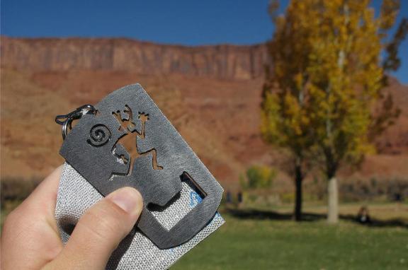
medal / bottle opener

Wednesday, October 10, 2012

Hidden Valley

For the next adventure with my sister, we took Megan on a 4-mile round trip day hike up to Hidden Valley.  This hike is close to Moab, and you get some great views of town and the Behind the Rocks area + some incredible rock art.


Anasazi rock art
switchbacks on the 700 ft. climb

To get to the trailhead, drive 3 miles south from Moab on U.S. 191 and turn right onto Angel Rock Road. After two blocks, turn right onto Rimrock Road and drive to parking area.

The trail takes you up some steep switchbacks to the top of the Moab Rim.  The trail is in great shape -- it's well marked and easy to follow.  After climbing around 700 feet, the hike levels out to Hidden Valley, which is pretty and grassy.  It's cool to look over the rim and see the town below.  Every time I've been there, it's been cold and shady, so if it's not summer, bring a jacket!

After hiking through the valley, the trail swings to the left and goes over a low pass.  You get some fantastic views of the Behind the Rocks area.  Best of all, the big butte on the right is coated with rock art.  Hop off the trail and skirt the bottom of the cliff to see loads of thousand-year-old petroglyph panels.  Both Anasazi and Fremont cultures overlapped here as they used this route to get into Spanish Valley.  Nice!  If you're feeling feisty and have a shuttle car, you can keep hiking to the Colorado River via the Moab Rim Trail.


looking out over Behind the Rocks area


Map credit:  http://www.blm.gov/ut/st/en/fo/moab/recreation/hiking_trails/hidden_valley_trail.html


Dead Horse Point -- Intrepid Trail

My sister Megan is out visiting!  HOORAY!  I love this kid and we always have a superfun time together.  She's hanging out in Utah for the next 2 weeks and we're packing in the deserty adventures.  I have to work, but the other Goblin folks are doing a great job keeping her entertained (i.e. Blue John Canyon and loads of Rolling Rock.)  Good stuff.


Sister!

On my days off we oscillated between turbo-girly (bought a wedding dress!) and epic (mountain biking!)  We swiped Jordan's mountain bike and went up to Dead Horse Point's Intrepid Trail.  This was Meg's first time on a mountain bike, so I wanted to pick something fun and easy.  But I totally didn't need to worry about it -- this girl is a TANK.  It was her first time out, but she was totally fearless.  Awesome.

Sister = BOSS

To get to the trail, you drive into Dead Horse Point State Park, pay the $10 entrance fee, and find the trailhead near the Visitor Center.  The trail is well-marked with signs at the intersections.  It consists of three concentric loops -- the Intrepid Loop (1.1 miles,) Great Pyramid Loop (4.2 miles,) and Big Chief Loop (8 miles.)  The trail surface is mostly packed with magnesium chloride, which is great to ride on.  It also doesn't have many big uphill sections or tricky technical chunks.  There are a couple spots where we hopped off to walk, but not a big deal.  Nice.

Half of the trail hugs the cliff's edge, which is incredible.  It's not close enough to be sketchy, but you get expansive views of the red-rock desert and the La Sals mountains.  Pretty hard to beat.  :) 

<3
off-trail at the DHP lookout
Intrepid Mtb. Trail

Friday, September 21, 2012

Half Marathon Training

Keep on keeping on ...

Our half marathon ("The Other Half - Moab Half Marathon") is exactly a month away, and we keep chugging along.  This week, the long training run was 8 miles, which felt long but manageable.  We'll bump up the long runs for one mile every week until we're ready for the entire 13.1.  So far the knees have been cooperating (knock on wood!) and the legs feel solid.  The brutal summer heat is finally fading, and running in the morning in 60-degree weather feels amazing.

I've been following the training schedule in the Non-Runner's Marathon Trainer, which got me through my first two half marathons.  The book works for me because it's geared towards people who aren't naturally talented runners and aren't shooting for a particular time.  Exactly.  I'm not going to break any land speed records here, but it's nice to feel solid and progressively stronger.

Wish me luck!


About Us