Showing posts with label mountain bike. Show all posts

Monday, May 20, 2013

Klonzo Mtb. Trails

We just hit the mountain bike trail jackpot!  After all the running around and planning of getting married last week, we were in the mood to take it easy and stay close to home.  Jordan had been hearing good things about the Klonzo Trail near Moab, so we drove an hour south to the trail head to check it out.

It ended up being the perfect spring day: 70 degrees, a sky was filled with puffy white clouds, and blooming desert flowers.  And the trails were incredible!  It was a totally different kind of Moab riding.  Moab trails tend to be technical and rocky (Slickrock, anyone?), but my favorite rides tend to be flowy and smooth like the volcanic tuft out in Fruita, CO.  Klonzo was the best of both worlds:  we had the red-rock desert of Moab with the flow trails of Fruita.  Awesome.


spiny hopsage

Like all the best trail systems, the Klonzo Trails make several concentric loop trails.  The seven trails of Klonzo are Boondocks, Borderline, Dunestone, Cross Canyon, Secret Passage, Snippet, and Wahoo.  Everything is ridiculously well marked -- there are signs at every intersection complete with 'you are here' markers.  You can piece the trails together however you want for a variety of riding experiences.

For the most part, these trails are smooth and flowy.  They're perfect for early-intermediate riders.  There are couple steep, tight spots and short climbs that might make true beginners nervous, but for the most part it's totally manageable.  Adrenaline junkies might be a little bored, but even more expert riders could enjoy these trails by riding faster and hammering out all the loops in a solid 12-mile ride.


whipple's fishhook

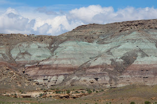
crazy turquoise of the Brushy Basin Member


To get to the Klonzo trailhead, drive along Highway 191 18 miles south of I-70 or about 10 miles north of Moab.  You'll see a sign that says "Willow Springs Road."  Turn here.  After about 1.4 miles, turn left to cross Courthouse Wash, and at mile 2.0 you'll go past the Soverign Trail parking area.  At mile 2.7, turn left off Willow Springs Road onto a small doubletrack.  100 feet later, park and begin your ride.

longnose leopard lizard


map credit:  blm.gov


Thursday, April 25, 2013

Luke's Trail

Price, UT is usually one of those places I visit for work and bureaucratic errands.  We're talking riveting activities like taking in water samples, getting a driver's license, and meeting with the BLM.  Fun stuff.  It's not a terrible town, it's just sort of utilitarian and unimaginative.

But if you dig a little deeper, there are really enjoyable places to visit.  (Isn't that always true?)  Price has a brewing company, a museum, and access to Nine Mile Canyon.  All good stuff.  This weekend, Jordan and I had to run a couple bureaucratic/utilitarian errands (e.g. getting a marriage license!,)  so we decided to try out some mountain bike trails in the area.


We drove just 0.5 mile north of town to the trailhead for Luke's Trails.  This area used to be totally trashed when locals would drive on top of the mesa and illegally dump their garbage.  A few years ago, a local mountain biker started cleaning up the mess and building unofficial guerrilla trails.  At first the BLM balked ("no environmental impact study?!") but they got on board once they saw how these volunteers had turned a trash heap into a great recreation area.

We started on Luke's Trail, which is a twisting singletrack on the mesa on the north edge of Price.  This intermediate-level trail winds through sage meadows and pinyon-juniper forests.  It also skirts the edge of the mesa for some great views of the Book Cliffs and the Roan Mountains.  The gray slopes sometimes look bleak, but when the sun hits them just right they have their own kind of subtle beauty.  We rode along Luke's Trail, took a short detour to Alan Alley, then looped back to the parking lot via the Cattleguard Cuttoff, S'mo Joes, and Knott Petes Rim.  The trail was fun, but it definitely has room for improvement.  Sometimes the trail surface was composed of big round rocks imbedded in soft tuft soil, so it was tough to keep a constant speed.  The trails also got closer to the cliff edge than it needed to be in some spots.  But for a volunteer-built trail so close to town, it was totally enjoyable.  I wouldn't plan my vacation around it, but it was a great way to polish off an errand-y weekend in Price.


The trailhead for Luke's Trail is just 1/2 mile from the north edge of town.  If you're eastbound on Highway 6, take the first Price exit.  Turn left (north) on 300 East. Drive to 900 North and turn left. The road will turn to dirt and/or narrow asphalt, and will veer right and climb the mesa.  0.5 mile later at the top of the mesa, fork left (west) and proceed 0.1 mile to the Lukes parking area.


map credit:  www.utahmountainbiking.com


Monday, April 1, 2013

San Rafael Swell hikes + bikes

Easter is typically the busiest weekend of the year down at Goblin Valley, and this year was no exception.  We were busting at the seams with people trying to slake their spring fever in 70-degree sunshine.  Great ... but exhausting.  Jordan and I both put in some crazy hours at work, then busted out for our weekend to find some much-needed solitude in the northern San Rafael Swell.


The northern Swell is rugged and gorgeous, and the dirt roads help keep visitation relatively low.  We drove up Buckhorn Wash and spent an afternoon wandering around the towering cliff walls and perennial streams in Calf, Cow and Pine Canyons.  The trailhead and parking area are located on Buckhorn Draw Road, just 2 miles north of the Swinging Bridge. These pretty canyons aren't exactly jaw-droppingly stunning, but they were totally enjoyable and perfect for an afternoon hike.

yellow stripes!


The next day, we dusted off the mountain bikes for the first time this spring and rode around the Good Water Rim trail.  Hells yeah!  This has to be one of the best trails in Utah -- it was all superfun intermediate riding and nonstop gorgeous views.  The whole loop is about 21 miles, and it skirts the edge of the Little Grand Canyon of the San Rafael River.  It's mostly cross-country singletrack that stays close (but not too close) to the cliff edge.  We had to cut the ride short because a sleety thunderstorm rolled in, but it was still fun.  I definitely want to come back and finish it up.


Wedge Overlook

map credit www.utahmountainbiking.com

Monday, November 12, 2012

Klondike Bluffs Mountain Biking

True story:  I'm a wimp in the winter.  Despite my best intentions, when the temperatures drop, the adventure momentum starts to wane.  It's a combinations of things:  the cold, the lack of light, and the holiday distractions.  It also doesn't help that we had no snow last year, which meant that all my good intentions to ski and snowshoe fell through.  And seriously, if it's going to be cold and dark, it might as well snow.

Unfortunately, so far this late fall/early winter has been just as dry as last year.  It's sunny and warm, with only a handful of half-assed flurries.  Don't get me wrong, I love the unseasonably warm weather as it's happening, but two mild winters in a row is going to turn southern Utah into a dry, dusty, drought-ridden mess.  Yikes.


So if we can't whip out the skis quite yet, it's time for Plan B:  keep biking.  It felt weird loading up the bikes with the sun at such a low, slanty angle, but we had a great time riding around the Klondike Bluffs mountain bike trails.


This was our first time riding around Klondike Bluffs, so we started on the Agate and Jasper loops.  These were super fun, easy trails.  I wish I would have learned to mountain bike here -- the trails are smooth and the hills are tame, but you still get some great views of the LaSals and surrounding desert.  On the Jasper Loop, you'll run into fields of the eponymous red stone, which is supercool.  Okay -- I've never been able to write this before -- but the trail was a little
too easy.  Definitely check it out if you're with kids or true beginners, but I'm itching to head back and try some of the tougher trails.

To get to the Klondike Bluffs Trail System, drive on Highway 191 8.5 miles south of I-70.  Watch for the "North Klondike" sign, and turn east (left.)  Keep to the right as the road winds south around a small hill.  Follow the signs to the trailhead.

riding through red jasper

map credit:  http://www.utahmountainbiking.com/trails/agate-jasper.htm

Wednesday, October 10, 2012

Dead Horse Point -- Intrepid Trail

My sister Megan is out visiting!  HOORAY!  I love this kid and we always have a superfun time together.  She's hanging out in Utah for the next 2 weeks and we're packing in the deserty adventures.  I have to work, but the other Goblin folks are doing a great job keeping her entertained (i.e. Blue John Canyon and loads of Rolling Rock.)  Good stuff.


Sister!

On my days off we oscillated between turbo-girly (bought a wedding dress!) and epic (mountain biking!)  We swiped Jordan's mountain bike and went up to Dead Horse Point's Intrepid Trail.  This was Meg's first time on a mountain bike, so I wanted to pick something fun and easy.  But I totally didn't need to worry about it -- this girl is a TANK.  It was her first time out, but she was totally fearless.  Awesome.

Sister = BOSS

To get to the trail, you drive into Dead Horse Point State Park, pay the $10 entrance fee, and find the trailhead near the Visitor Center.  The trail is well-marked with signs at the intersections.  It consists of three concentric loops -- the Intrepid Loop (1.1 miles,) Great Pyramid Loop (4.2 miles,) and Big Chief Loop (8 miles.)  The trail surface is mostly packed with magnesium chloride, which is great to ride on.  It also doesn't have many big uphill sections or tricky technical chunks.  There are a couple spots where we hopped off to walk, but not a big deal.  Nice.

Half of the trail hugs the cliff's edge, which is incredible.  It's not close enough to be sketchy, but you get expansive views of the red-rock desert and the La Sals mountains.  Pretty hard to beat.  :) 

<3
off-trail at the DHP lookout
Intrepid Mtb. Trail

Tuesday, September 18, 2012

La Sal Mountains -- Warner Lake

Fall is here!  It's still toasty down in the desert, but when we drove up to the La Sal Mountains this weekend it was a yellow aspen extravaganza.  I'm the world's biggest sucker for aspens -- everything was crisp and golden and perfect.


Warner Lake aspen grove

The Loop Road up to the LaSals has been closed for a couple months (construction?) so we drove up through the Sand Flats Recreation Area.  We'd never taken this route before, but I think it's going to be the new standard!  As you climb 5,000 feet up into the mountains, the terrain changes from red slickrock to lush pines.  It's a gravel road, but it's only about 36 miles from Moab, so the trip didn't take much longer than going past Ken's Lake. 

Warner Lake + Haystack Mountain

We set up the teardrop at
Warner Lake campground (9,200.')  I love seeing Haystack Mountain reflected in the little reed-lined lake.  There's loads of hiking trails, aspen groves, and a perfect little white cabin that makes my heart skip a beat.  Can I live here one day?

We didn't really have a specific trail in mind -- we just tooled around on our mountain bikes and hiked wherever it looked pretty.  We found a couple sections of trail that were fun on the bikes, but I think the real draw is the Whole Enchilada Trail.  I can't wait until I'm pro enough to tackle this monster.  A shuttle vehicle takes you to the top of Burro Pass (11,200',) then you bomb down 26.5 miles and 7,000 vertical feet to the Colorado River!  One day.  Patience, grasshopper.


Instead, we opted for a hike towards Beaver Basin.  It was one of those hikes that was supposed to be short and quick, but the scenery kept pulling us in.  Eventually, we made it to the saddle between Mount Waas and Manns Peak.  Jordan scurried up to the top of one of the mini-summits, then we hobbled back down.  Great weekend.  Fall is definitely my favorite season!

Beaver Basin Trail

Tuesday, June 26, 2012

Durango

We had noble intentions of being cheap and sticking around Moab this weekend, but man.... it's hot.  This has been a brutal summer so far and the draw of a cool mountain town was impossible to resist.  So we loaded up the bikes and drove east to Durango, CO.  I'd never been before, but all accounts sounded promising -- a snazzy mining town that evolved into an outdoor recreation mecca with loads of trails and breweries.  Hells yeah!

On the drive out, we saw a forest fire near Mancos.  This year has been really hot, dry, and windy -- Utah and Colorado are giant tinderboxes.  We watched a helicopter collect water and drop it on the flames as they climbed up the mountain.  Yikes.

Forest fire near Mancos, CO

We eventually made it to Durango and started putzing around the historic downtown.  Durango has a lot of Victorian-era brick hotels and saloons that have been turned into shops and restaurants.  The Animas River runs through town, and college kids were floating in tubes down the whitewater.  We also scoped out the Durango/Silverton Narrow Gauge Railroad, which snakes up the mountains on steam-powered trains.  Our aimless wandering turned into an epic pub crawl, so we grabbed a hotel and crashed for the night.

Strater Hotel in historic downtown Durango

The next morning we were decidedly more ambitious.  We stopped by a bike shop for trail recommendations, then drove up to the Colorado Trail.  The ride started out easy and pretty as we scooted along a clear mountain stream lined by pine trees.  Then we started climbing.  And climbing.  The mountain bikers bombing downhill assured us it was worth it, but I'm not gonna lie -- I wasn't loving it.  We finally made it up to the top and had some sweeping views of tree-lined slopes and distant peaks.  Nice.

Riding along the Colorado Trail.

My trusty steed.

Made it!


Tuesday, June 12, 2012

Fruita Mountain Biking + Palisade Wine Tour

This weekend was a bike extravaganza!  Jordan and I hopped over the Colorado boarder to ride the fun, flowy mountain bike trails around Fruita.  The next day, we biked around the wineries and orchards of Palisade.

At first glance, the area around Grand Junction seems like a bland, utilitarian cow town.  Typically when I go to the Junc, it's to stock up on Colorado beer or catch a flight.  But the more time I spend in the area, the more I appreciate Junction.  It's right next to Colorado National Monument and the Book Cliffs.  It has a handful of snazzy restaurants and breweries in its revitalized downtown.  There's a couple nice museums (animatronic dinosaurs, anyone?) and a pretty botanical garden.  I was already leaning towards becoming a Junction fan, and these last couple days totally sealed the deal.  Grand Junction is neat -- I'm officially converted!

PBR (Pumps, Bumps, and Rollers)

collared lizard
On our first day out, we rode the mountain bike trails just outside Fruita.  Fruita trails sometimes get overshadowed by Moab, but they're starting to get attention as some of the best single-track mountain bike trails in the United States.  (Seriously!)  We camped and road in the 18 Road / Book Cliffs area, which is fun and flowy.  I rode the Kessel Run, Prime Cut, PBR, and Joe's Ridge.  I've never ridden on soft volcanic soil like this, and it was a nice change from Moab's rocky steps.

Joe's Ridge
Free campground in the middle of all the trails.

The next day, we drove 24 miles east of Fruita to the town of Palisade.  Palisade is home to some of Colorado's best vineyards.  Family farms, hot summers, and volcanic soil combine to produce some bold, tasty wines.  The area is beautiful, too -- rows of grapes and peaches are surrounded by the imposing grey Book Cliffs.  We rode our bikes to a couple wineries, a meadery, and a distillery.  Most of them were open for tasting, so by the end of the trip, we were feeling goooood!


Tuesday, April 10, 2012

Circle O

For the second time out on my mountain bike, I tried some slickrock on the Circle O trail.  Slickrock (especially the infamous Slickrock Trail) made Moab the center of the mountain biking universe.  This naked sandstone earned its name from early settlers riding metal-shod horses.  However, for mountain bikes the opposite is true -- the rock grips tires like sandpaper.


Circle O is a good introduction to slickrock riding -- the BLM classifies it as beginner/intermediate.  Head up to the MOAB Brand Trail system, and start on Bar M or North 40.  You'll quickly reach Circle O, which is a 3-mile ride designated by a rust-colored line.  It doesn't have any major climbs or really technical spots, but it's full of dips and turns.  The views of Arches National Park and the La Sal mountains are incredible.


I'm feeling more confident on my bike, but I'm definitely still a rookie.  Riding on slickrock was neat, but it takes getting used to.  I noticed some pros and cons ...

(+)
-- Gorgeous and novel.  It looks like a sidewalk of orange rock.
-- Lots of options.  You're not confined to one path like a singletrack trail.
-- No sand or loose rocks.

(-)
-- Lots of quick ups and downs.  You can't really zone out or "flow."
-- Jarring.  All that hard rock rattles you around.
-- Painful.  Yeah, don't fall.


MOAB Brand Trail System.  Circle O is dark blue. (Map credit:  http://www.utahmountainbiking.com/).

About Us