Tuesday, October 16, 2012

Goblin's Lair Rappel

Embarrassing fact about me:  I almost never stay in Goblin Valley on my days off.  Of course it's a really cool park to work at and there are loads of places I haven't explored.  But for some reason, when my weekend rolls around I want to drive far, far away.  Maybe it's just hard for me to relax when I'm hiking around the park -- it's impossible for me to flip off the 'work' switch.  I start picking up litter, telling people not to carve their names into rocks, building cairns, etc. and suddenly I'm no longer having a relaxing weekend.  It feels like work.

Welcome to my office -- please take a seat!

But it's different when people are out visiting.  Newbies are seeing everything with a fresh perspective, and their enthusiasm is contagious.  It's nice to experience things again with a fresh set of eyes.  So for my sister Megan's last weekend out, we headed into Goblin Valley for a rappelling expedition into the Goblin's Lair.

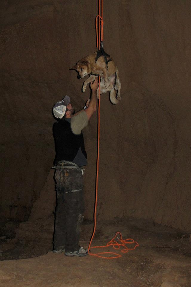
78-foot free rappel! (See Megan?)

Goblin Valley has a handful of spooky/neat caves.  They're not really caves in the classic, limestone cavern sense, but they're snazzy little alcoves made of a Entrada Sandstone.  One of them is tall enough that you can do a 78-foot free rappel into it.  It looks like a huge gothic cathedral with soaring sandstone walls and weird goblin-y texture.  We recruited our rappelling guru Nathan, who hooked us up with harnesses and rope, and started our hike towards the back of the park.

hiking in

Not to mix business with pleasure, but Goblin Valley just set up a backcounty rappelling permit system this year, so make sure you stop by the Visitor Center to fill one out before you do any technical rappelling in the park.  They're free and unlimited -- we're just trying to gage use numbers and watch the resource impact.

Anyway, the top of the rappel route isn't marked, and it takes a little scrambling to find it.  A GPS and map definitely come in handy.  Climb-Utah.com has a great, detailed map and description of the route.  Once you get to the top, you'll see some webbing above a hole.  You put on your harness, hook in, scoot up to the edge, and eeeeease back into an alternate universe!  Getting over the lip of a rappel always makes me nervous, but once you're hanging, there's nothing to it.  Supercool.

going down ...
weeeeeee!
Luke's turn

Once everyone is down, you hike out to the back of the cave.  From there, you head north, hook up with the Carmel Canyon trail, and hit the parking lot.  Nice!

heading out of the Lair 
the hike back

Wednesday, October 10, 2012

Hidden Valley

For the next adventure with my sister, we took Megan on a 4-mile round trip day hike up to Hidden Valley.  This hike is close to Moab, and you get some great views of town and the Behind the Rocks area + some incredible rock art.


Anasazi rock art
switchbacks on the 700 ft. climb

To get to the trailhead, drive 3 miles south from Moab on U.S. 191 and turn right onto Angel Rock Road. After two blocks, turn right onto Rimrock Road and drive to parking area.

The trail takes you up some steep switchbacks to the top of the Moab Rim.  The trail is in great shape -- it's well marked and easy to follow.  After climbing around 700 feet, the hike levels out to Hidden Valley, which is pretty and grassy.  It's cool to look over the rim and see the town below.  Every time I've been there, it's been cold and shady, so if it's not summer, bring a jacket!

After hiking through the valley, the trail swings to the left and goes over a low pass.  You get some fantastic views of the Behind the Rocks area.  Best of all, the big butte on the right is coated with rock art.  Hop off the trail and skirt the bottom of the cliff to see loads of thousand-year-old petroglyph panels.  Both Anasazi and Fremont cultures overlapped here as they used this route to get into Spanish Valley.  Nice!  If you're feeling feisty and have a shuttle car, you can keep hiking to the Colorado River via the Moab Rim Trail.


looking out over Behind the Rocks area


Map credit:  http://www.blm.gov/ut/st/en/fo/moab/recreation/hiking_trails/hidden_valley_trail.html


Dead Horse Point -- Intrepid Trail

My sister Megan is out visiting!  HOORAY!  I love this kid and we always have a superfun time together.  She's hanging out in Utah for the next 2 weeks and we're packing in the deserty adventures.  I have to work, but the other Goblin folks are doing a great job keeping her entertained (i.e. Blue John Canyon and loads of Rolling Rock.)  Good stuff.


Sister!

On my days off we oscillated between turbo-girly (bought a wedding dress!) and epic (mountain biking!)  We swiped Jordan's mountain bike and went up to Dead Horse Point's Intrepid Trail.  This was Meg's first time on a mountain bike, so I wanted to pick something fun and easy.  But I totally didn't need to worry about it -- this girl is a TANK.  It was her first time out, but she was totally fearless.  Awesome.

Sister = BOSS

To get to the trail, you drive into Dead Horse Point State Park, pay the $10 entrance fee, and find the trailhead near the Visitor Center.  The trail is well-marked with signs at the intersections.  It consists of three concentric loops -- the Intrepid Loop (1.1 miles,) Great Pyramid Loop (4.2 miles,) and Big Chief Loop (8 miles.)  The trail surface is mostly packed with magnesium chloride, which is great to ride on.  It also doesn't have many big uphill sections or tricky technical chunks.  There are a couple spots where we hopped off to walk, but not a big deal.  Nice.

Half of the trail hugs the cliff's edge, which is incredible.  It's not close enough to be sketchy, but you get expansive views of the red-rock desert and the La Sals mountains.  Pretty hard to beat.  :) 

<3
off-trail at the DHP lookout
Intrepid Mtb. Trail

Tuesday, September 25, 2012

San Rafael River backpack

Sweetbabyjebus, I love fall.  It seems like we spend all summer running away from the bone-dry, scorching-hot desert.  Don't get me wrong, I love summer vacations to far-away places, weekends up in the mountains, and splashing around in the kayak.  But as summer winds down and there's a break in the relentless heat, I fall in love with southern Utah all over again.  THIS is why I live out here.  I love feeling my feet move over grippy slickrock as I gaze up at soaring red cliffs.  I love tucking into hidden canyons to find 2,000-year old rock art.  I love epic sunsets followed by inky black, star-peppered skies.  This, ladies and gentlemen, is what it's all about.

Whoa.  Sorry about the melodramatic preamble.  Anyway, we backpacked the San Rafael River Gorge this weekend.  It was neat.


View from the top -- we backpacked down in the gorge.
San Rafael River

The San Rafael River is a beautiful little river that meanders through a gigantic uplift in the earth's crust.  We hiked the 16.6 mile hunk known as the "Little Grand Canyon," where the canyon walls rise a thousand feet above the river to form the Wedge Plateau.  There's lots of epic canyons, interesting rock art, and an abandoned mine.  Supercool.


Hiking the San Rafael River is a little logistically funky.  First of all, you have to check the water levels (the USGS updates them here.)  During the hike, you'll ford the river about 15 times, and that's easiest to do when the river is running below 120 cfs.  If it's over 150 cfs you might as well float it in a ducky!  Late summer and early fall have the lowest water levels.  We lucked out -- this has been one of the driest years on record, so the river was only 13 cfs.  No problemo.


13 cfs = superlow water

Next, you have to do the shuttle BS.  Take two cars, then drop one off at the San Rafael swinging bridge, where you'll finish the hike.  After that, drive together 18.3 miles (about 1 hour) to Fuller Bottom and drop your other car here.  A 2WD can make it, but it's pretty sandy, so keep the speed up!  We did all the shuttling business the night before so we could start at a decent time.

At long last, it's time to hike!  Beautiful, beautiful, beautiful.  The trail isn't really marked, but there's a decent path you can follow most of the way.  There are a couple places that are choked with tamarisk and some annoying river crossing with steep muddy banks, but don't get discouraged -- for the most part it's flat and easy to follow.  The silty water is pretty murky and would probably clog your filter in a couple pumps, but it's fun to slosh through!  And the hike is wonderful.  The red-rock canyon walls are steep and impressive.  You pass a little copper mind from the late 1800s that burrows 2,000 feet into the mountain.  After 7.2 miles, you'll get to Virgin Spring Canyon.  It's one of the few places that isn't heavily grazed by cattle, and there's a reliable spring not too far from its entrance.  There's also a pictograph panel about 1/4 mile from the mouth of the canyon.  We set up camp here and spent the night being serenading by frogs.  :)


Virgin Spring Canyon rock art

The next day, we hiked 9.4 miles back to the Swinging Bridge.  On this day, we entered the deepest section of the canyon that lies just below the Wedge Overlook.  People can drive to an overlook on the cliff's edge, and we saw an ant-sized guy waving at us from the top!  The trail was gorgeous, the rabbit brush were blooming yellow, and we saw a bighorn sheep.  It rained a little bit in the afternoon, but not enough to make us worry about flash floods.
RAIN!?!?
desert bighorn

All in all, it was a great trip.  It feels good to be out in the desert again.  I'm pretty obsessed with the northern San Rafael Swell right now and I'm itching to explore more places up there.

Friday, September 21, 2012

Half Marathon Training

Keep on keeping on ...

Our half marathon ("The Other Half - Moab Half Marathon") is exactly a month away, and we keep chugging along.  This week, the long training run was 8 miles, which felt long but manageable.  We'll bump up the long runs for one mile every week until we're ready for the entire 13.1.  So far the knees have been cooperating (knock on wood!) and the legs feel solid.  The brutal summer heat is finally fading, and running in the morning in 60-degree weather feels amazing.

I've been following the training schedule in the Non-Runner's Marathon Trainer, which got me through my first two half marathons.  The book works for me because it's geared towards people who aren't naturally talented runners and aren't shooting for a particular time.  Exactly.  I'm not going to break any land speed records here, but it's nice to feel solid and progressively stronger.

Wish me luck!


Tuesday, September 18, 2012

La Sal Mountains -- Warner Lake

Fall is here!  It's still toasty down in the desert, but when we drove up to the La Sal Mountains this weekend it was a yellow aspen extravaganza.  I'm the world's biggest sucker for aspens -- everything was crisp and golden and perfect.


Warner Lake aspen grove

The Loop Road up to the LaSals has been closed for a couple months (construction?) so we drove up through the Sand Flats Recreation Area.  We'd never taken this route before, but I think it's going to be the new standard!  As you climb 5,000 feet up into the mountains, the terrain changes from red slickrock to lush pines.  It's a gravel road, but it's only about 36 miles from Moab, so the trip didn't take much longer than going past Ken's Lake. 

Warner Lake + Haystack Mountain

We set up the teardrop at
Warner Lake campground (9,200.')  I love seeing Haystack Mountain reflected in the little reed-lined lake.  There's loads of hiking trails, aspen groves, and a perfect little white cabin that makes my heart skip a beat.  Can I live here one day?

We didn't really have a specific trail in mind -- we just tooled around on our mountain bikes and hiked wherever it looked pretty.  We found a couple sections of trail that were fun on the bikes, but I think the real draw is the Whole Enchilada Trail.  I can't wait until I'm pro enough to tackle this monster.  A shuttle vehicle takes you to the top of Burro Pass (11,200',) then you bomb down 26.5 miles and 7,000 vertical feet to the Colorado River!  One day.  Patience, grasshopper.


Instead, we opted for a hike towards Beaver Basin.  It was one of those hikes that was supposed to be short and quick, but the scenery kept pulling us in.  Eventually, we made it to the saddle between Mount Waas and Manns Peak.  Jordan scurried up to the top of one of the mini-summits, then we hobbled back down.  Great weekend.  Fall is definitely my favorite season!

Beaver Basin Trail

Tuesday, September 4, 2012

Ridgway

Ridgway, Colorado is one of my favorite places in the world.  Our friends, Jerry and Diana, have a house there, and during the summer we love to visit them and escape the desert heat.  It's pretty much perfect -- gorgeous mountains, cool temperatures, loads of aspens, and nearby hot springs.  It's always amazing to start driving after work, get there in the dark, and wake up to an unbelievable view of the Sneffels Range.


Sneffels Range

The view from the porch was gorgeous as always, but it was a little disconcerting this time around.  Usually there's a layer of snow coating the uppermost peaks, even in summer.  But now the peaks look totally bare!  Jerry has been in the San Juans for decades, and he's never seen a year with no snow.  Spooky.  This year has been so ridiculously dry.

The next morning we took the quads up to the Uncompahgre National Forest to hike around and have lunch.  We rode through endless aspen groves, then built a little fire.  A storm rolled through, but we all ducked under a patch of trees and munched away.  By now a little rain is sort of a nice novelty!

Uncompahgre National Forest
lunch!

Jordan and I spent the rest of the rainy afternoon at Orvis Hot Springs.  Orvis is a natural hot springs resort near Ouray with water that ranges from 98-112 degrees.  It also naturally contains lithium, which makes you feel super relaxed and loopy.  There's a couple big pools, the "lobster pop," a sauna, and two massage yurts. Ahh ...

We spent Monday at the Ridgway Rodeo, which was a blast.  I haven't been to a rodeo since I was a little kid, and we had a great time downing beers and watching crazy people ride bronchos and bulls.  Seriously, who was the first guy to decide that riding a pissed off bull was a great idea?  It was fun to bask in a bunch of balls-out Labor Day Americana, although I feel like I should eat some granola or tie-dye a shirt to maintain my hippie credentials...

Ridgway Rodeo
Jerry and Diana

About Us