Friday, April 12, 2013

McConkie Ranch -- Dry Fork Canyon Archaeological Site

The rock art around Vernal is unbelievable.  I've seen a lot of rock art in Utah, but the classic Vernal style is really distinct.  These images were created by the Fremont people around 800-1,200 years ago.  The figures tend to be trapezoid-shaped anthropomorphs with elaborate headdresses, necklaces, and earrings.  It's impossible to know exactly what rock art represents, but to me these figures seem a lot more war-like and foreboding.  Many of them are carrying shields and decapitated human heads.  Spooky, but really cool.

check out those feet!

After work at the Field House, two coworkers and I went to explore the rock art at the McConkie Ranch.  There are dozens of intricate, well-preserved panels carved and painted onto the cliff walls.  The images are located on private property, but thankfully everything is open to the public.  A rough trail runs along the edge of the cliffs below the rock art, and the three of us spent an hour or so gawking and speculating.  It's definitely some of the most impressive, distinct rock art I've seen in Utah.

Three Kings panel

To reach the ranch, drive to downtown Vernal and then get onto 500 North Street. Follow that street west to 3500 West Street. Turn north and follow 3500 West to the McConkie Ranch Road. It is about 6.4 miles from the 500 N/3500 W intersection to the ranch road turnoff. As you follow 3500 West it becomes the Dry Fork Canyon Road.  A sign clearly marks the turnoff to McConkie Ranch. Follow the McConkie Ranch Road for about 1/2 mile to the signed parking area. All these roads are paved.

From the parking area, the Main Trail is clearly marked and leads immediately up the cliff to the rock art. The 3 Kings Trail also begins at the parking area. You have to hike through ranch fields to get to the rock art along the 3 Kings Trail, but it is well worth the effort. Follow the trail markers over a fence and through fields, and then up the cliff to the rock art. Keep going until a sign indicates you have reached the trail's end. From that point you will have a clear view of the 3 Kings Panel.


Thursday, April 11, 2013

Utah Field House of Natural History

Sweet!  This week, I actually got paid to go to a new place.  The Utah Field House of Natural History State Park Museum had its grand opening for the new curatorial facility, so a bunch of park employees (including Jordan and I) went to help out.  The Field House is a dinosaur extravaganza showcasing fossils found throughout the Uinta Basin.  The outside of the building is surrounded by life-size dinosaur replicas, including a Tyrannosaurus with six-inch teeth, a horned Triceratops, six-ton Stegosaurus, and a winged Pteranodon.  The inside of the museum reveals over 600 million years of life, from the Pennsylvanian to the Pleistocene.  You could definitely spend a solid days investigating all the artifacts.  My favorite exhibit is the wall of fossilized leaves -- each rock with the fossil imprint was shaped into a rectangle, then mounted on a green wall.  It's art.


grand opening!
fossilized leaf wall

However, very few museums can display all their artifacts, and the Field House is no exception.  The curatorial facility is a humidity- and temperature-controlled building where they keep fossils, bones and other artifacts they don't have room to show in the museum.  It won't typically be open to the public, but for the grand opening the community was invited to get a 'behind the scenes' look.  Each park employee had an artifact to talk about, so I pretended to be an expert on fossilized turtle shells for a day.  Sweet!


The Field House is located at 496 East Main Street, Vernal, UT 84078-2605.  To reach them, call (435) 789-3799.


Jordan + ridiculous Unterman paintings


Wednesday, April 10, 2013

Grand Gulch: Big Man Panel + Mule Canyon

Spring in Utah can be a little schizophrenic -- over the course of a day the weather can oscillate between 70-degree-sunny-gorgeous or windy-blowing-sleet-nasty.  We had a little of both this weekend down in Grand Gulch, but surprisingly the nasty sleety day ended up being a really cool desert experience.

We busted out after work and drove down to Grand Gulch.  Grand Gulch is a serpentine canyon that delves into the otherwise gently sloping surface of Cedar Mesa, and it's packed with Ancestral Puebloan (aka Anasazi) rock art and ruins.  The Anasazi thrived in Grand Gulch between 800 and 2,000 years ago, and they left behind some incredible cliff dwellings and petroglyphs.  You have to hike into the canyon to see these artifacts, and for the most part nothing is signed or marked.  That feeling of wildness and discovery makes Grand Gulch one of my favorite places in Utah.  Of course, parks like Mesa Verde and Chaco are incredible, but all the people, fences, and pavement make the ruins seem sort of artificial and sanitary.  It's a totally different experience to be miles from pavement and searching for hidden cliff dwellings that are still surrounded by undisturbed pottery sherds, corn cobs, mano/metate, woven mats, etc.


milkvetch
  
On this trip, we did a couple day hikes.  On the first day, we trekked 10.6 miles (round trip) down to the Big Man rock art panel, which was incredible.  The panel shows life-size figures that are surrounded by hand prints.  I love rock art hand prints -- there's something so essentially human about them.  We also explored a couple nearby structures and granaries.  If you're planning a hike into Grand Gulch, I'd recommend bringing Trail's Illustrated Grand Gulch map and David Day's Utah's Incredible Backcountry.  They both show and describe the main features down in the gulch, which is especially helpful for things that aren't visible from the canyon floor.

To get to the Big Man panel, drive 13.5 miles south from the junction of Highway 95 and 261 near Natural Bridges National Monument.  After passing the Kane Gulch ranger station and a couple other trail heads, you'll see a sign on the east side of the road that says "Cigarette Springs."  Take the unmarked road on the opposite (west) side of the highway.  You'll follow a good dirt road for about 7.5 miles.  There are a couple intersections, but just keep following the signs that say "Government Trail."  The last 1.5 miles of the drive are on a rough dirt road, and we ended up putting the Jeep in 4WD to get over a couple spots.  This will get you to the start of the Government Trail.

Start your hike on the Government Trail.  The first 2.8 miles of hiking are on an old 4WD road, which is still fairly scenic.  You'll finally reach the edge of the plateau and get a great view into Grand Gulch and Polly's Canyon.  Start the 620 ft. descent to the canyon bottom, then head 1.6 miles north upstream.  The Big Man panel is about 200 feet above the canyon floor and you can't see it from the canyon bottom.  It's a little tricky to find, so remember that about 1.2 miles upstream from Polly's Canyon you'll see another large side canyon coming into Grand Gulch from the east.  Just after this point, the streambed swings to the west, creating a bulge in the canyon wall.  The rock art is up on this bulge --  watch for a little cairn and a sandy social trail on your right.


Big Man Panel
800-year-old hand prints

The next day, we explored the Anasazi ruins in Mule Canyon.  The hike is about 10 miles round trip, but give yourself lots of time to climb up and explore everything.  The start of the hike didn't look too promising, because the canyon bottom was coated in tumbleweeds and a nasty storm was brewing.  But I'm really glad we pushed on.  We saw some incredible ruins -- one or two every mile!  As we were hiking, a chilly rain started to fall.  Normally we don't hike in desert canyons during a rainstorm, but Mule Canyon was wide and dry enough that we weren't worried about a dangerous flash flood.  It was really cool to watch as water started flowing down the canyon walls and dry creak beds.

To get to Mule Canyon, drive east on Highway 95 past the entrance to Natural Bridges National Monument.  After 9.1 miles, you'll see a gravel road on the north side of the highway leading up to Texas Flat.  Turn left, drive 0.3 miles, and you'll see a little kiosk down inside the canyon on the left side of the road.  Start hiking here.


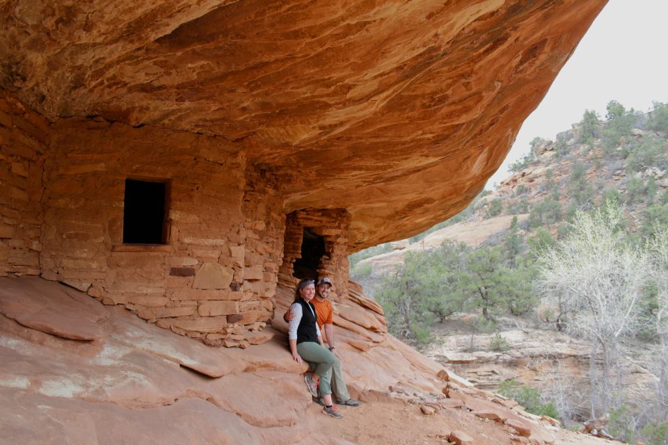
House on Fire

Monday, April 1, 2013

San Rafael Swell hikes + bikes

Easter is typically the busiest weekend of the year down at Goblin Valley, and this year was no exception.  We were busting at the seams with people trying to slake their spring fever in 70-degree sunshine.  Great ... but exhausting.  Jordan and I both put in some crazy hours at work, then busted out for our weekend to find some much-needed solitude in the northern San Rafael Swell.


The northern Swell is rugged and gorgeous, and the dirt roads help keep visitation relatively low.  We drove up Buckhorn Wash and spent an afternoon wandering around the towering cliff walls and perennial streams in Calf, Cow and Pine Canyons.  The trailhead and parking area are located on Buckhorn Draw Road, just 2 miles north of the Swinging Bridge. These pretty canyons aren't exactly jaw-droppingly stunning, but they were totally enjoyable and perfect for an afternoon hike.

yellow stripes!


The next day, we dusted off the mountain bikes for the first time this spring and rode around the Good Water Rim trail.  Hells yeah!  This has to be one of the best trails in Utah -- it was all superfun intermediate riding and nonstop gorgeous views.  The whole loop is about 21 miles, and it skirts the edge of the Little Grand Canyon of the San Rafael River.  It's mostly cross-country singletrack that stays close (but not too close) to the cliff edge.  We had to cut the ride short because a sleety thunderstorm rolled in, but it was still fun.  I definitely want to come back and finish it up.


Wedge Overlook

map credit www.utahmountainbiking.com

Tuesday, March 26, 2013

Bike Touring

Jordan laaaaavs bikes.  Moab mountain biking lured him out to Utah in the first place.  Weirdly, he doesn't discriminate between the rabidly distinct bike subcultures like a lot of guys do -- if it has two wheels and a frame, he's into it.  He shifts easily between high-speed lycra-clad road cycling to fat-tire slickrock without paying any attention to snotty sects.  The only bike I can't imagine him riding is a hipster fixie with an ironic scarf.  I knew our relationship was for real when he bought a backpack and I bought a bike!

panniers vs. trailer

Early spring weather is perfect for bike rides, so we decided to go on a mini bike tour this weekend.  Bike touring is when you mix backpacking and road biking  -- you load all your camping gear into panniers or a trailer and hit the road.  We've been geeking out on the  Adventure Cycling Association website the America ByCycle blog, and I had some new panniers I wanted to try out.

old route 24

It was fun!  We stayed close to home and tooled around SR-24, then camped tucked away off the side of the road.  Even though I drive this road to work every day, I noticed a lot more at this pace.  Honestly, I'll probably always gravitate more towards hiking -- I like the simplicity of less gear and wild places further from pavement -- but I can imagine covering a lot of ground this way it seems like a great way to see the country. 


Tuesday, March 19, 2013

Cassidy Arch

It's almost the one-year anniversary of this blog!  My first entry was about last year's trip down to Capital Reef National Park, so it's sort of appropriate that's where we headed this weekend -- we always seem to start off the spring season down there.  This weekend was equal parts wedding planning and hiking.  Jordan and I are eloping in the park in a couple months, so we spent the first day meeting people, checking out the hotel and filling out permits.  We spent the night in the campground, then busted out for a day hike up to Cassidy Arch.


Spring!  and a polarized lens!
Northern Flicker in the campground

The 7-mile loop hike out to Cassidy Arch is never that far from pavement, but you still feel like you're a world away from the historical orchards along the main highway.  That's one of my favorite things about Capitol Reef -- there's so much variety.  You can see 800-year-old rock art, pick fruit in historic orchards, and see some of the craziest, most wildly colorful geology in Utah.  This hike takes you up to the top of the Waterpocket Fold, and you're rewarded with a tangle of red and white canyons, arches, and spires.  


There are a couple logistical details to take care of before you start hiking.  We started the hike across from the Hickman Bridge trail and finished at the Grand Wash trailhead along highway 24.  That means there's a 2-mile road walk between the start and the finish.  You can either walk the road, drop off a shuttle car, or a hitch a ride.  We got lucky and caught a ride with the first car that drove by.  If you have a backpack and make a sign that says "Hickman Bridge Trail," most people will figure you're not too sketchy!


colorful canyons

The hike starts with a 1,040 ft. climb along the Frying Pan trail up near the top of the Waterpocket Fold.  The views are incredible.  After around 3 miles you start dropping back down.  Make sure to take the 0.4 mile detour out to Cassidy Arch, named after the outlaw Butch Cassidy who was thought to have occasionally use these canyons as a hideout.  In the early afternoon light, the arch is huge, impressive, and easy to walk across -- it's thicker than it looks from the overlook!


Cassidy Arch

After checking out Cassidy Arch, you continue the decent down into Grand Wash.  To finish up the hike, you stroll an easy 2.5 miles through a flat, sandy wash surrounded by towering cliff walls.  Great hike.


Grand Wash

Monday, March 4, 2013

Green River Stables horseback riding lessons

Yup, I have the coolest fiance in the history of the world.  For Christmas, Jordan got me horseback riding lessons at Green River Stables!  I've ridden horses several times before, but it's always been on quick, superficial trail rides.  Now I get to learn more about horse care, grooming, and psychology.  Sweet!


Jordan and I drove up to Green River Stables this morning for our first lesson.  It's a really comfortable, low-key place that offers trail rides, lessons, and boarding.  The stables are located right along the Green River with the Book Cliffs towering overhead -- it's definitely picturesque and quintessentially Wild West.  They don't have their own website, but they're located at 2735 North Long Street in Green River, UT and their phone is (435) 564-3554.


shedding their winter coats
We met the owner, Terry, who is really fun and down-to-earth.  She introduced us to Chester and Sooka, our horses for the day.  We groomed the horses, put on their bridles and saddles, and learned the proper way to approach and touch a horse.  For the rest of the day, we got to ride around the pen and learn the basics -- different ways to sit in the saddle, getting the horses to go left and right, stopping, and going faster.  Towards the end of the lesson, Terry tried to teach us how to trot, which was tricky.  She explained trotting is the most efficient gate for a horse, but it's kind of rough on the rider.  I've ridden a trotting horse before and it totally kicked my ass, but Terry showed us a couple different techniques and by the end we sort of got it.  It was great -- I've always really liked horses, but this gave me a whole new level of understanding.  Definitely looking forward to the next lesson!


Jordan + Chester


About Us