Thursday, July 25, 2013

Lower Fox River

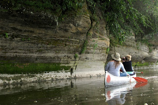
We're back in the flatlands for our wedding reception!  Jordan and I eloped in May, but we still wanted to have the big ol' party back home with all our friends and family in Illinois.  I also really wanted a bachelorette party with my buddies (Although, I guess it's not a legit bachelorette party if you're already married, but whateva-i-do-what-i-want!)  Semantics asides -- we had a great time.  I'm not a big fan of bar-hopping with penis necklaces and pink martinis, so my little sister planned a fantastic canoe trip along the Lower Fox River.  Much more my scene.  :)


Obviously, a big group and tons of booze aren't conducive to super-ambitious trips, so we decided to do a short 6-mile stretch of the river.  The Lower Fox River is a pretty tributary of the Illinois River.  Its dark green waters roll by white sandstone bluffs dotted with little alcoves. Everything was covered with white pines, sassafras, Ohio buckeye, and blue beech.  We also saw a bunch of classic flatland critters -- deer, cliff swallows, and squirrels.


We rented canoes from Ayers Landing Canoe Rental ($50/canoe, includes shuttle.)  They dropped us of at the put-in at Highway 52, and we paddled right up to the take-out at their office.  Convenient.


That night, we stayed in two cabins at Mallard Bend Campground.  The campground was definitely clean and well-maintained, but it was waaaay spendy ($105 per cabin?!)  Any other night I would have opted to stay in a less-expensive IL state park, but for some inconceivable reason, IL state parks don't let you drink in their campgrounds.  Come on, it's my bachelorette party!  So we shelled out the extra money and made the most of it.


All in all, it was a great trip.  Amid all the girly details of wedding planning, it was really nice to get outside and be ornery with my best buddies.  :)


Friday, July 12, 2013

The Big Ol' Promotion

Whoa!  Sometimes life moves at warp speed, and this month has been a big one.  I went up to Oregon to interview for a park job on the coast, but that didn't work out.  THEN my boss got a big ol' promotion and is moving on to greener pastures up in Salt Lake City, leaving me to fill his shoes.  So that means as of August 3, I'll be the Park Manager of a three-park complex!  And in the meantime we're having the wedding reception and going on our honeymoon.  It's all good stuff, but ... yikes.

So with all that in mind, the blog might have to go on hiatus for a couple months while I'm running around like a crazy person.  I'll still try to post, but cut me some slack if things are a little half-assed!  Wish me luck!

Monday, July 8, 2013

La Sals Mountains / Clark Lake Trail


It’s HOT down in the desert!  After two solid weeks of temperatures hovering around 100 degrees, it was definitely time to head up to the mountains.  We packed up the truck with almost no ambition except to park our asses by an alpine lake and cool off.  The La Sal Mountains are our token go-to summer retreat.  They stand over blistering Moab promising a 20-degree temperature drop, green aspens, running streams, and tiny remnants of snow.  Places like this make summers in southern Utah bearable.

This time, we drove up to Blue Lake, which is a pretty little lake just over Geyser Pass.  We set up our tent near the lakeshore, and with the exception of a family who came up to fish, we had the place to ourselves.  The first day we did a whole lot of nothing – sat, read, watched ducks swim around, and soaked up a spattering of rain.  It was all perfectly relaxing until Jordan took a stroll around the lake and saw a momma bear with her two cubs!  Needless to say, we didn’t have the soundest sleep that night, but I guess it’s good practice for our upcoming backpacking trip in the Wind Rivers.


Blue Lake
Note to self:  Don't leave the camera on macro!
The next day, we went on a 6-mile hike down to Clark and Oowah Lakes.  The first part of the hike was a never-ending field of wild flowers -- lupine, Utah daisies, Sego lilies, mules ear, scarlet gilia, etc.  We looped down to Oowah Lake, then back up through groves of aspen.  The trail doesn’t lose or gain a lot of elevation like most La Sal trails, but you still get a solid variety of landscapes.  This route is also popular with downhill mountain bikers, so keep an eye out for them – they’re moving fast!

To get to the Lake Clark trailhead, head up Geyser Pass Road in the La Sal Mountains.  A mile or so before you hit the actual pass, you’ll see a small dirt pull-off and a sign that says Clark Lake.  Start your hike here.  The hike makes a cherry shape, so you’ll hike downhill along Trail 141 about 1.3 miles until you get to Clark Lake.  From there the trail makes a loop down to Oowah Lake.  Either way works – we started on the northern part of the loop, went down 2.3 miles to Oowah Lake, then returned to Clark Lake via Trail 144.  Good stuff!


About Us